Japan's Earthquake, Tsunami and Nuclear Disaster of 2011

At 2:46pm local time, on 11 March 2011, Japan suffered one of the worst natural disasters in history. This huge composite disaster had many shocking elements, namely:
- that it should happen to a highly developed nation;
- that another event, on the same scale as the Boxing Day 2004 tsunami, should occur so soon after;
- that Japan was hit by an earthquake, tsunami and a potential on-going nuclear disaster.
Earthquake
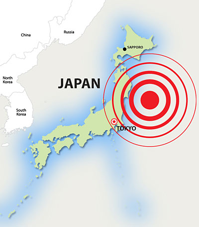
Two days beforehand, there had been major tremors in the region, peaking at 7.2 on the Richter scale. But the earthquake measuring 9.0 was the world’s 5th largest since 1900 and the largest in Japan
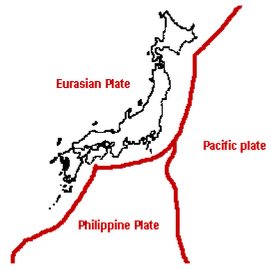
since instrumental records began 130 years ago. The epicentre, 24 km deep, was 72 km off the coast of Sendai, where the Pacific Plate is being subducted below the Okhotsk Plate, which carries northern Japan.
The 1 in 1000 year event was due to seismic waves travelling along many interlinked fault systems for 500 km, building up energy as they went, and three earthquakes occurred consecutively. Horizontal crustal displacement of the seafloor was measured at 50m, and the seabed was raised by 16 m. Ground shaking occurred afterwards for 6 minutes. Within 20 minutes, a huge tsunami had developed and began to inundate the coastal lowlands. 5 weeks after the disaster, the region had experienced 420 aftershocks greater than magnitude 5.0, suggesting that there will continue to be large scale crustal adjustment.
Factors that contributed to the high vulnerability of the area:
- Off Sendai, there is very old oceanic crust and, being cooler and denser, was thought to readily slide into the mantle, so only small earthquakes were expected.
- Warping of the Pacific Plate means it gets stuck rather than slides smoothly into the mantle, so strain quickly builds up.
- The coastline is rugged and jagged with many inlets, known as a ria coast. Waves become concentrated in bays, which focus wave energy on to land and especially up rivers.
- 70% of Japan is mountainous, forcing urban and industrial development into narrow, low-lying coastal areas.
- Soft reclaimed land is susceptible to ground shaking, causing landslides.
- The Prime Minister accepted that government officials were too complacent and had come to believe in technological infallibility.
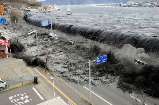
Tsunami
The first tsunami warning was issued only three minutes after the earthquake for Iwate, Miyagi and Fukushima Prefectures, and within 45 minutes the 800 km long coastline to Chiba Prefecture was alerted to prepare for a 10 m or higher tsunami.
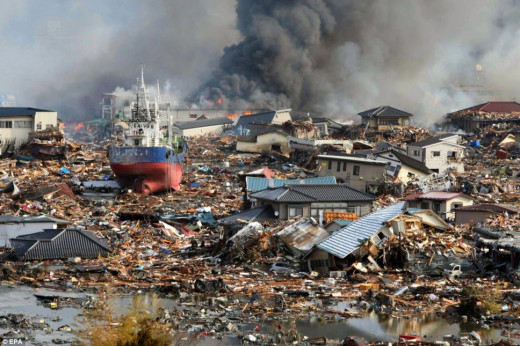
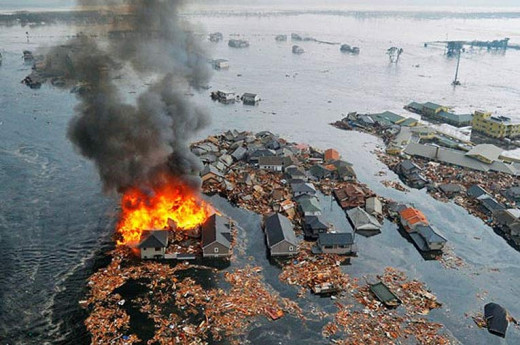
The highest wave height was 15 m and this reached the nearest coastline within 30-40 minutes. The massive force of water hit the coast, causing erosion of beaches and dunes by the inrush of turbulent water, and destroyed man-made structures such as seawalls and 95% of all vegetation. In total, 500 km sq were inundated in north-east Japan.
The tsunami also affected the area by transporting huge amounts of sediment, up to 5 km inland on the Sendai Plain. Sand from the beaches and the shallow seabed was picked up and transported landwards, and as energy dropped, the load was deposited in paddy fields and forests. Some of the seawater from the run up of the tsunami remained on the surface for two months, and salt crusts formed in the paddy fields as water slowly evaporated.

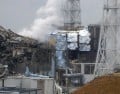
Fukushima Nuclear Explosion
The most serious consequence of the tsunami was the damage to the Tokyo Electric Power Co.’s Fukushima No.1 nuclear power plant, which supplied 6% of the company’s energy. There were six reactors – three were not operating, and the other three shut down successfully in response to the earthquake. However, two tsunami waves arriving 40-50 minutes later inundated the power station.
In any nuclear reactor, water is heated to form steam. This drives turbines that in turn generate electricity. When the earthquake happened, the reactors automatically closed down but because the power supply had been damaged by the tsunami, the cooling system in the basement failed, allowing water to heat and to continue generating steam. The fuel rods got hotter and reacted with steam to form hydrogen gas and actually melted, causing damage to the power station’s structure. Pressure rose until there was an explosion and the hydrogen was released. In response, managers used seawater as an emergency coolant and sprayed it over the reactors. After the explosion, radioactive substances escaped and fires developed.
Impacts
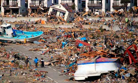
Immediate impacts were to buildings and infrastructure, water and sanitation, food and fuel supplies but then secondary impacts set in. These included physical and psychological impacts on the local population that made the rescue effort more difficult. Due to the scale of the inundation run-up, some designated tsunami shelters were within the flooding zone and failed to save lives.
A coastal forest, designed as an artificial breakwater, failed completely. Giant breakwaters, the largest in the world, had been built in the bay mouths to protect major cities such as Kamaishi and Ofunato, but the tsunami destroyed these structures, although they did reduce damage to some extent.
Deaths
The final death toll was around 20,000 with 3,000 never accounted for, making it the 20th most deadliest earthquake and tsunami in the last 100 years. In terms of actual numbers, the worst hit city was Ishinomaki, but Otsuchi lost 10% of its total population (nearly 2000). 65% of the victims were aged over 60 years old, demonstrating the repeated experience in natural disasters that the elderly are most vulnerable. In Otsuchi, the most heavily-affected town, many disaster-relief officers themselves were killed and it proved impossible to set up a recovery operation for a week, when trained people from other areas arrived.
Economic Losses
In the short term, there was an impact on production, both in Japan and globally, as supply chains were affected but some companies recovered after six months to pre-quake levels, showing the resilience of Japan’s economy. Some fear that improved figures are the result of the reconstruction effort and that economic activity will decrease with time.
Building and Infrastructure Loss
The main earthquake lasted 0.2 - 1.0 seconds, causing more than 300,000 buildings to be destroyed, and another million damaged. Almost 4,000 roads, 78 bridges and 29 railways were also affected, and 72.6 % of all structures in the port city of Ishinomaki were destroyed The Japanese government estimated damage to buildings and infrastructure at more than $300 billion, making it the world’s costliest natural disaster.
Event
| Buildings Destroyed
| Buildings Partially Destroyed
| Buildings Partially Damaged
| % of Total Damage
|
|---|---|---|---|---|
Earthquake
| 13,000 – 18,000
| 75,000 – 100,000
| 540,000 – 570,000
| 46%
|
Tsunami
| 100,000 – 105,000
| 80,000 – 100,000
| 45,000 – 70,000
| 44%
|
Nuclear Disaster
| An estimated 35,000
| uninhabitable buildings lie within the
| Fukushima exclusion zone.
| 10%
|
Impact of Fukushima Nuclear Explosion
80,000 people in a 12-mile radius had to be evacuated due to radiation contamination. In December 2011, at the same time as the Fukushima plant was declared stable, (but decades before the area is decontaminated and people can return), 800 from the town of Futaba were still living in an abandoned school 100 miles away.
There has been concern about radiation in the food chain. Unsafe levels of caesium-137, which has a half-life of 30 years, were reported in beef, due to cattle being fed contaminated hay. Contamination was found in soils and crops up to 40 km away from Fukushima, and whilst the open ocean seems not to be affected, the near-shore sediments (up to 20 km offshore) were badly affected and hence seafood has high levels of caesium.
Environmental Impacts
Due to the mountainous nature of Japan, the earthquake triggered many landslides on the steep slopes, as well as causing slope failure of flood protection schemes such as earth walls. Reclaimed land suffered liquefaction on soft alluvial plains and there was a huge transfer of sediment from seabed to land. The weight of sediment within the tsunami wave contributed significantly to building damage. The canals allowed water and sediment to penetrate inland and they became sediment traps as the energy dispersed, requiring dredging. The massive and sudden change to coastal ecosystems will have implications for fishing and farming.
Why did preparation systems fail?
Japan has some of the most advanced preparedness plans for natural disasters in the world and yet it proved susceptible to an unexpected, though not unknown, mega-event. Although it had coped with earthquakes of magnitude 8.0, a 9.0 quake is 30 times more powerful and design features were not built for this, and therefore neither were human response systems.
Japan is home to the world’s densest seismometer network and most extensive earthquake early-warning system. Seismic maps show probabilities of scale and occurrence. However, Japan’s latest seismic hazard map of 2009 predicted the region having a magnitude of 7.7 (the largest in history forthe area), with only a 30-40% chance in the next 10 years. Predictions also assumed there would be a point source of energy, not a rupture that interlinked different fault systems. In addition, protection systems only cope up to an 8.0 magnitude. Frequent aftershocks confused the warning systems.
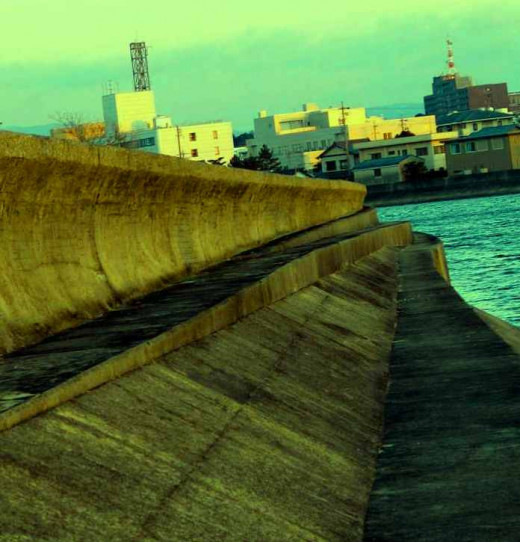
In 2008, after 30 years of construction, a $1.4 billion tsunami wall was completed. It was 8m high, 20m thick and 2km long. The foundations went down over 60m. Unfortunately, this was built to withstand, at maximum, 4-5m tsunamis from earthquakes of magnitude 7.5.
Preparedness Successes
It should be noted that well-learnt preparedness drills and education programmes did much to save some communities. Tsunami hazard maps had been distributed to all households, and workshops to find local evacuation routes had been promoted. Some schools in Kamaishi got 3000 children to high ground as soon as the earthquake was felt, not waiting for official alerts. Vertical evacuation in the Sendai region saved many lives. The Japanese Earthquake Early Warning system provided up to 90 seconds’ warning of the earthquake for some residents in Tokyo.
The Government's Immediate Response
In April 2011, one month after the disaster the recovery programme was established on three principles: safety, sustainability and compassion. The region is to be rebuilt to be highly resistant to natural disasters, together with social systems which recognise the need to live sustainably and which care in particular for its vulnerable members.